
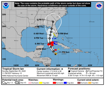
 Nothing ruins the calendar more than a change in the weather. Example: For today’s blog I had planned a deep dive into Tuesday's county commission agenda. It now falls into the “who cares” category as our eyes turn to Ian. That’s the way it is in the blog/news biz. There’s only one lead headline and a potential hurricane on the way grabs it any day of the week.
So, of course, I have some thoughts: —First, the important stuff: Sandbag sites are open Monday in Homosassa and Crystal River. Click here for details. Make sure to check the county’s or sheriff’s Facebook pages for updates throughout the week. — As we prepare for whatever is coming, know this: These things are incredibly fickle. Ian’s path may change right up to the last minute. — Weather is the ultimate people story because politics can’t get in the way. Weather is weather. We prepare, hunker down during it, and then reconstruct afterwards. — That said, it’s also a political story of course because the government gets involved. When the Citrus County EOC is activated (it wasn’t as of Sunday night), all the local agencies gather to ensure the community is protected when and if the storm arrives. Politics, generally, take a back seat during hurricane threats. I can’t recall the last time county commissioners had a difference of opinion about hurricane response. —The biggest storm didn’t have a name at all: the March 1993 “no-name” storm. We knew a storm was coming but no one understood the magnitude of it. It was a Saturday. The phone rang around 6 a.m. and it was Chronicle photographer Dave Sigler. Evacuations were starting west of U.S. 19 as the coastal communities were being inundated with water. And it wasn’t just a coastal event. High winds spawned tornadoes and brought damage throughout the county. But there’s one thing that stands out. It was during this storm, the entire county was in crisis mode on that Saturday, when the newsroom phone rang and I answered it. On the line was the activities director of a local nursing home. The newspaper photographer had not shown up for the monthly crowning of King and Queen residents. Proving once again: What’s of importance to me isn’t always important to you. — Hurricane Hermine never made landfall but in 2016 it slid up the Gulf Coast, dumping rain and pushing water in with the tides. The result was “no-name” 2.0. As if I wasn’t sure, Larry Brock called me at 2 a.m. the night of the storm when water was up past his knees on U.S. 19 in Crystal River. “It’s 'no-name' all over!” Brock, then the county’s assistant public works director, said. I wrote many stories for the Chronicle post-Hermine. Lots of folks in Crystal River, Homosassa and Ozello lost homes or learned the hard way about FEMA rules in trying to rebuild. And don't even get me started about The Islands condominium post-Hermine fiasco. — A year later came Irma, and Irma scared me. I was the lead reporter on Irma coverage, which means I was all over it for days. Frankly, too much information. I believed all those experts who said this thing was going to snake up the Florida coast and smack Citrus County right upside the head. If ever there was a sure thing of a Category 3 hurricane rocking our community, this was it. As Irma approached Saturday night, streets were empty, shelters full. Most churches had canceled Sunday services. Deb and I rode out the storm with our cat, Molly, at the Chronicle office in downtown Inverness. We had plenty of provisions: boxes of Hostess cupcakes, Little Debbie snacks, chips, crackers and Cheez Whiz. (Gerry Mulligan: "Whaaaat? I didn't approve this. Cat?") I was on the phone throughout the night with Lee Alexander from the sheriff’s office, who said the storm’s path had changed and weakened suddenly. By the time it passed through Citrus, Irma was downgraded to a tropical storm. We still had power outages and it was pretty uncomfortable around here for a few days, but to go from a potential Category 3 or 4 to a tropical storm in a matter of hours was significant. — Hurricane Ian is on its way. The message, as always: Stay safe, Citrus. Join the discussion on our Facebook page. Comments are closed.
|
AuthorMike Wright has written about Citrus County government and politics for 36 years. 


Archives
July 2024
|